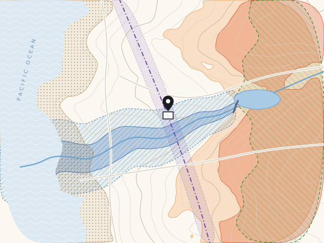
Special flood hazard area
Is the property in one of FEMA's zones with a 1% or greater chance of flooding in any year (Zones A and V)? Lenders often require flood insurance there.
Mapped by FEMA
Our new ordering platform is live. Returning customers: the first time you sign in, we'll email you a link to set a new password. Your past reports are waiting. Sign in
California Natural Hazard Disclosure reports
Enter the property, choose your report, and order, all on one page. Most reports arrive in about a minute, with real-time hazard maps you can check the moment you order.
Tap a zone to see it on the map.
~1 min
Most reports are delivered in about a minute.
Live maps
Real-time hazard maps you can check as soon as you order.
E&O
Backed by errors & omissions insurance for the transaction.
Saved
Escrow, agent and TC contacts are kept for your next order.
What's covered
California Civil Code §1103 requires sellers and their agents to tell buyers whether a property lies in any of these state or federally mapped zones. Your report makes each determination and shows where it came from.
Is the property in one of FEMA's zones with a 1% or greater chance of flooding in any year (Zones A and V)? Lenders often require flood insurance there.
Mapped by FEMA
Could the property flood if an upstream dam failed? The state maps these areas of potential flooding from dam inundation studies.
Mapped by the CA Department of Water Resources
The State Fire Marshal rates fire hazard as Moderate, High or Very High based on expected fire behavior. Maps for local responsibility areas were updated in 2025.
Mapped by the Office of the State Fire Marshal
Is the property in wildland where the State of California is primarily responsible for fire protection? These areas carry their own fire-prevention requirements.
Mapped by CAL FIRE
Is the property inside an Alquist-Priolo Earthquake Fault Zone, drawn around active faults where the ground surface could rupture?
Mapped by the California Geological Survey
Is the property in ground mapped for possible liquefaction or earthquake-induced landslides? These zones can require site studies before building.
Mapped by the California Geological Survey
Hazard maps are estimates. Being in or out of a zone doesn't predict whether a property will be damaged, and an NHD report isn't a home inspection, a geologic study or an insurance decision.
Reports
Every NHD report covers the six statutory determinations and comes with real-time hazard maps. Order any of them on one page.
Residential
The statutory natural hazard disclosure for a home sale, with tax disclosure.
Residential Most complete
Everything in the Residential NHD, plus environmental screening for the property.
Commercial
The natural hazard disclosure for commercial property, with tax disclosure.
Commercial
Everything in the Commercial NHD, plus environmental screening.
Rentals
For landlords: shows whether a rental is in a special flood hazard area or an area of potential flooding, so the tenant disclosure is accurate.
Add-on New
The property's permit history, to help spot permit-related issues before they surface in escrow.
How it works
Start with the address. The whole order happens on one page.
Pick the report and add the escrow officer, agents or TC. We save them for next time.
Most reports arrive in about a minute, with real-time hazard maps to review right away.
Wildfire disclosures
The State Fire Marshal released updated Fire Hazard Severity Zone maps for local responsibility areas in 2025. Homes in high and very high zones can carry added disclosure requirements, including the Fire Hardening and Defensible Space disclosure under AB 38.
The report preview now flags when that disclosure may be required, so it's handled at listing instead of discovered in escrow.
Order a reportResources
Consumer booklets that often travel with an NHD, plus the official maps behind each determination. Every link goes straight to the publishing agency.
Guides buyers often receive alongside the NHD.
En español
Look up the maps behind each determination.
State and federal databases for due diligence.
California law requires sellers and their agents to tell buyers whether a property sits in certain mapped hazard zones (Civil Code §1103). An NHD report checks the official maps for the property and prepares the Natural Hazard Disclosure Statement, so the disclosure is accurate and documented.
The disclosure goes to the buyer as soon as practicable before the transfer of title, so most listing agents order it when the property goes on the market. That way it's ready to hand over with the rest of the seller's disclosures.
Most reports are delivered in about a minute after you order, and you can check the real-time hazard maps right away.
No. It reports whether the property is inside officially mapped zones. Maps are estimates: they don't predict whether a property will be damaged, and an NHD isn't a home inspection, a geologic study or an insurance decision. For property-specific questions, talk to the right licensed professional.
Ordering now happens on a single page, the report preview flags when the Fire Hardening and Defensible Space disclosure may be required, and your order history and downloads are all in one place. The first time you sign in, we'll email you a link to set a new password.
California requires residential landlords to disclose certain flood-hazard information to tenants. The Tenant Flood Report shows whether the rental is in a special flood hazard area or an area of potential flooding, so what you disclose is accurate.
Yes. Sign in and your order history and report downloads are there. Trouble signing in? Email support@logicnhd.com.
Phone
858-413-7578Office
13400 Sabre Springs Pkwy #100
San Diego, CA 92128